Trail Walking La Bégude-de-Mazenc - La Bégude de Mazenc - Serre de Forillon - Photo

La Bégude de Mazenc - Serre de Forillon

 tracegps
tracegps

User

© OpenStreetMap contributors
Length
Length
8.1 km
Max alt
Max alt
475 m
Uphill gradient
Uphill gradient
293 m
Km-Effort
Km-Effort  
12 km
Min alt
Min alt
211 m
Downhill gradient
Downhill gradient
296 m
Boucle
Boucle
Yes
Creation date :
2014-12-10 00:00:00.0
Updated on :
2014-12-10 00:00:00.0

(1 Reviews)

Walking
Walking
2h30
Difficulty : Medium

Scan this QR Code to open this trail in the SityTrail application

FREE GPS app for hiking

Logo SityTrail SityTrail

IGN / Geographical institutes

Download SityTrail from the App Store Download SityTrail from Google Play

Logo SityTrail SityTrail World

The world is yours!

Download SityTrail from the App Store Download SityTrail from Google Play Download SityTrail on Huawei AppGallery

About

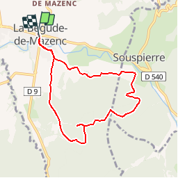
Trail Walking of 8.1 km to be discovered at Auvergne-Rhône-Alpes, Drôme, La Bégude-de-Mazenc. This trail is proposed by tracegps.

Description

Sur le haut du "Serre de Forillon" point de vue magnifique, vue de la région de St Gervais, Marsanne, Dieulefit et vue sur les montagnes d'Ardèche. A faire de préférence un jour avec un mistral faible.

Elevation profile

Positioning

Country:
France
Region :
Auvergne-Rhône-Alpes
Department/Province :
Drôme
Municipality :
La Bégude-de-Mazenc
Location:
Unknown
Start:(UTM)
653670 ; 4934219 (31T) N.

Comments

Please log in to post a review or rate the element


Très sympathique s'il n'y avait pas eu toutes ces mouches.


Trails nearby

Trail Walking Portes-en-Valdaine - GPX-Rando-Plaine-Portoise-nouvelleversion - Photo
Walking
GUIDE
thonyc

Walking

Easy
(1)
Portes-en-Valdaine, Auvergne-Rhône-Alpes, Drôme, France
7.1 km | 8.2 km-effort
2h 0min
Yes
Trail Walking Portes-en-Valdaine - Portes-en-Valdaine Serre-de-Mirabel 11km. - Photo
Walking
chancha

Walking

Difficult
(1)
Portes-en-Valdaine, Auvergne-Rhône-Alpes, Drôme, France
10.8 km | 14.7 km-effort
3h 20min
Yes
Trail Walking La Touche - La Touche Crêtes de l'ysard 12km. - Photo
Walking
chancha

Walking

Difficult
(1)
La Touche, Auvergne-Rhône-Alpes, Drôme, France
12.1 km | 16.8 km-effort
3h 48min
Yes
Trail Walking Portes-en-Valdaine - 26 portes en valdaine - Photo
Walking
GUIDE
randodyssée

Walking

Very easy
Portes-en-Valdaine, Auvergne-Rhône-Alpes, Drôme, France
10.6 km | 14.5 km-effort
4h 10min
Yes
Trail Walking La Touche - Citelles hameau et ruisseaux 10km - Photo
Walking
GUIDE
thonyc

Walking

Easy
(2)
La Touche, Auvergne-Rhône-Alpes, Drôme, France
9.6 km | 12.6 km-effort
3h 7min
Yes
Trail Cycle La Bégude-de-Mazenc - La Roche St Secret - Photo
Cycle
tracegps

Cycle

Medium
(1)
La Bégude-de-Mazenc, Auvergne-Rhône-Alpes, Drôme, France
46 km | 56 km-effort
2h 10min
Yes
Trail Walking La Bégude-de-Mazenc - 2022-12-16_08h55m45_tmpWriteApidae_269688_fr-1 - Photo
Walking
chancha

Walking

Difficult
La Bégude-de-Mazenc, Auvergne-Rhône-Alpes, Drôme, France
8.3 km | 12.3 km-effort
2h 44min
Yes
Trail On foot Portes-en-Valdaine - Rando des 15 en courant #26 - Photo
On foot
Julie LABBE

On foot

Medium
(1)
Portes-en-Valdaine, Auvergne-Rhône-Alpes, Drôme, France
19.4 km | 27 km-effort
6h 9min
Yes
Trail Walking La Touche - La Touche : Les Citelles et Serre Pointu 12km - Photo
Walking
chancha

Walking

Difficult
La Touche, Auvergne-Rhône-Alpes, Drôme, France
12 km | 16.6 km-effort
4h 3min
Yes


Close
My subscriptions